Best Urban Tree Inventory Software in 2026: The Buyer's Shortlist
The best urban tree inventory software in 2026, by job and region: TreePlotter and TreeKeeper in the US, Ezytreev in the UK, R3 GIS in Europe, and more.

What is the best urban tree inventory software in 2026?
The best urban tree inventory software in 2026 depends on where you work and what you manage. In the US, TreePlotter or TreeKeeper, which publishes prices for its first two tiers. On ArcGIS, Esri's Tree Management. In the UK, Ezytreev. In Europe, R3 GIS GreenSpaces. For free benefit estimates, i-Tree, with a funding caveat. To connect a tree inventory with planting, stewardship and site records, Restoration Scope.
As of October 2026: facts about each tool come from its own website or documentation, linked in each entry, and were checked on October 19, 2026. Prices change; confirm them with the provider.
Key takeaways
- Region narrows the field fast. US vendors tend to build around ISA and i-Tree, UK vendors around councils, QTRA and CAVAT, and European vendors around stability assessments, though several sell across regions. Check each vendor's local support and the methods you need.
- Few vendors publish prices. Davey's TreeKeeper publishes two tiers ($3,600 and $8,000 a year), a PlanIT Geo page puts TreePlotter from $1,500 a year, and Ezytreev's G-Cloud listing gives £1,000 a licence a year. Expect to ask the rest for a quote.
- Many features are add-ons. Work orders, risk forms, offline collection and benefit calculations are often priced separately. Compare the bundle you need, not the base plan.
- Plan for i-Tree's uncertainty. It's still free, but its traditional federal hosting and maintenance funding is suspended. Keep your inventory in a format you can analyse elsewhere.
- Inventory is the start, not the job. The value is in inspections, maintenance and planting kept against each tree over years.
What urban tree inventory software is (and what it isn't)
An urban tree inventory is a record of every tree a city, campus, park or stewardship group looks after. Inventory software keeps that record current and connects it to the work done on each tree.
It covers six jobs:
- Inventory: each tree's location, species, size and condition.
- Field updates: inspections and new trees recorded on a phone or tablet, often offline.
- Work orders and maintenance: pruning, removals and planting, assigned and signed off.
- Risk assessment: structured tree risk or stability forms, such as ISA, QTRA or visual stability assessments.
- Public map and engagement: a map residents can browse, and a way for them to report trees.
- Benefits and canopy: estimates of carbon, stormwater, cooling or amenity value, and canopy cover.
It isn't an arborist's judgment or a canopy plan. Software records an assessment; a qualified arborist makes it. Canopy maps from satellites or aerial imagery show cover, not individual trees, so they complement an inventory rather than replace it. For field data collection in general, see our guide to field-data apps.
How we chose these tools
We checked each tool on five criteria you can verify on its own website:
- Jobs covered: how many of the six jobs above the tool's own site says it does, including paid add-ons.
- Region served: where it says it works, and the standards it names.
- Offline field app: whether field staff can record without a connection.
- Published price: whether its price is on its website, and the entry price.
- Data you keep: whether it states an export or API for your data.
We didn't score ease of use, support or data quality, because we can't measure them fairly across tools. This is an editorial shortlist by region and job, not a ranking: US tools first, then UK, Europe, free tools, and Restoration Scope, our own product, last.
The best urban tree inventory software in 2026
Eleven tools, grouped by region and the job each is built for.
1. TreePlotter, best for US cities that want modules to grow into
TreePlotter, from PlanIT Geo, covers inventory, work orders, reporting and outreach, online or offline. Work orders, an electronic ISA level 2 risk assessment form, the Offline Collector and Eco Benefits are add-ons, and its Community Engagement Map gives residents a public view. Its product page says "Request Pricing"; a PlanIT Geo marketing page says it starts from $1,500 a year. PlanIT Geo said in March 2025 that it hosts 18 million trees across 21 countries.
Best suited for: US municipalities, states and nonprofits that want one vendor for inventory, outreach and canopy (through its separate TreePlotter CANOPY product). Price the add-ons you'll need.
2. TreeKeeper, best for published, unlimited-user pricing
TreeKeeper, from Davey Resource Group, handles inventory, work orders and ecosystem benefits, online or offline, with unlimited users and data, and a public Guest View map. Tier 1 with API costs $3,600 a year and Tier 2 $8,000; Tier 3 is quoted. It integrates with 311, Cartegraph and Cityworks, and TreeKeeper Canopy adds yearly canopy data.
Best suited for: small and midsized North American cities, campuses and cemeteries that want a known price. Its site mentions noting potential risks but names no risk assessment standard.
3. ArborPro, best when you also want the inventory collected for you
ArborPro is a US urban forestry consulting firm that sells GIS tree inventory software with an offline iOS Collector app, work orders, ecological benefits through i-Tree compatibility, and a Community Viewer share link. It says it has completed more than 750 street tree and open space inventories in more than 35 states. Data exports as CSV. Price not published.
Best suited for: US cities that want a consultant to collect the inventory and software to keep it. Hazard assessments are sold as a service rather than described as a software feature.
4. Esri ArcGIS Tree Management, best for cities already on ArcGIS
Tree Management is an ArcGIS Solutions template for public works and parks departments: a Field Maps map for inventory, inspection and maintenance, Workforce for field assignments, a Survey123 form for resident requests, and a public Hub site. It needs ArcGIS Online, ArcGIS Pro, Workforce, Field Maps and Survey123 Connect, and a Creator user type to deploy. Esri has announced Workforce's retirement in its Q4 2026 releases, with Field Maps Tasks as the replacement, so check the transition. Esri sells user types as annual licences; we didn't find their prices on its ArcGIS Online purchase page.
Best suited for: cities whose GIS team already runs ArcGIS. It names inspections but no risk standard or benefit calculation.
5. Ezytreev, best for UK and Irish councils
Ezytreev, from RA Information Systems, covers tree inventory, tree preservation orders, works orders and budgets, QTRA risk assessment, CAVAT amenity valuation and an offline app for Android, iOS and Windows. Its ezyPortal gives residents a public tree map, and it can connect to the i-Tree Eco-Benefits API. It says more than 200 organisations manage 3.5 million trees with it. Its supplier-written G-Cloud 14 listing gives £1,000 a licence a year; confirm modules and setup costs.
Best suited for: UK and Irish councils and their contractors who work with QTRA and CAVAT.
6. Arbortrack, best for councils that want a long-established UK system
Arbortrack, from Arbortrack Systems with TriNova Systems, maps trees on Ordnance Survey MasterMap with cyclical work orders, contractor sign-off and inspection scheduling. It says more than 90 UK councils use it, and it was developed in 1996. Its tablet app works offline, including where there's little or no signal, and syncs in the background. It supports What3Words locations; ask the vendor about a public map. Data connects through WFS and exports to Shapefile and Excel. Price not published.
Best suited for: UK councils focused on inspections and works. Teams that want a public map should check the fit.
7. R3 GIS GreenSpaces, best for European cities and green-space teams
R3 GIS GreenSpaces, from Bolzano, Italy, manages trees, shrubs and play equipment, with visual and instrumental stability assessments, job planning, an offline mobile app, a public portal for residents and a BENEFITS module. It says it manages more than 2 million trees for more than 250 customers in over 15 countries. Data exports as XLS, SHP and PDF. Price not published.
Best suited for: European municipalities and contractors that manage trees alongside other green assets.
8. greehill, best for LiDAR-based inventories of large cities
greehill, with offices including Budapest, builds tree inventories from street-level LiDAR scans and AI, with more than 70 data points per tree, storm-risk metrics and climate benefits. Its platform then handles inspections, prioritisation and work orders, and completed work updates each tree. Data exports as CSV and SHP, with GeoJSON on request. It says more than 130 cities use it, covering more than 3 million trees. Price not published.
Best suited for: large cities that want an inventory captured at scale rather than tree by tree, then managed in the same platform. Smaller teams recording trees one by one may prefer a field-first tool.
9. i-Tree, best free tool for tree benefits
i-Tree, from the USDA Forest Service and partners, estimates tree benefits for free: Eco evaluates an existing inventory, and Canopy estimates cover from aerial imagery. Eco also includes mobile field forms and complete inventories, but it's an assessment workflow, not a maintenance or work-order system. In December 2025 its traditional hosting and maintenance funding from the USDA Forest Service was halted; project funding continues, the team has committed to at least six months' notice before a core tool goes offline, and May 2026 funding from CAL FIRE and the Forest Service's International Programs restored office hours.
Best suited for: any team that wants benefit estimates from its inventory. It isn't inventory management, and its long-term future is uncertain, so keep your data exportable.
10. QField, best free option for a team with a GIS analyst
QField is a free, open-source app that takes QGIS projects into the field, offline. QFieldCloud sync is free on its Community plan, then €18 per user a month on the Flat plan billed annually (€14 from 20 users, or €23 billed monthly), or €28 per active user on Flex. Nothing comes set up for trees; you build the forms, layers and reports in QGIS.
Best suited for: small teams and stewardship groups with someone who knows QGIS and a tight budget. See QField vs Restoration Scope.
11. Restoration Scope, best for connecting tree records to planting and stewardship work
Restoration Scope (that's us) builds digital infrastructure for nature projects: we connect a team's field data, maps and workflows so they can see their operations and show funders credible evidence. For urban trees, that means locations, species and size beside the city's own tree records, organized by neighborhood, ravine or planting site; visits with observations and photos recorded on a phone against each tree; and the next round of monitoring started from the site map.
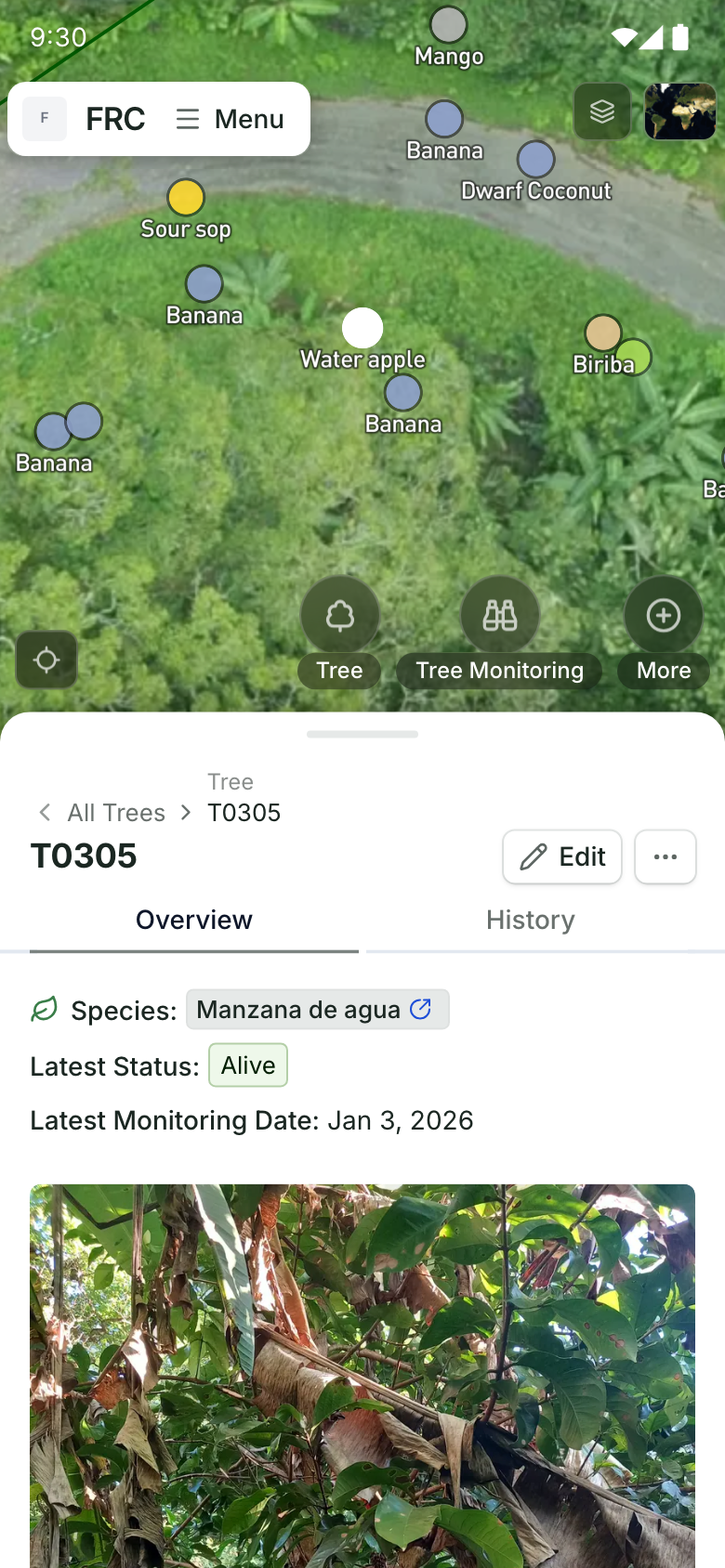
One tree's record on a phone.
Its species, latest status and last monitoring date, with its field photo. A real tree record from Alegría FRC.
We're not a municipal work-order or risk-assessment system, and we don't calculate benefits. Pricing is a free demo, then a platform license plus implementation, quoted after a scoping call.
Best suited for: stewardship programmes, tree charities and city teams whose inventory, planting and volunteer records live in separate places. See Restoration Scope for urban forestry.
Also considered
- OpenTreeMap's open-source code hasn't been updated since August 2023; confirm who hosts and maintains it before relying on it.
Google Environmental Insights Explorer offers a free preview of environmental data for more than 40,000 cities, including tree canopy for some. It's canopy data, not an inventory.
Side-by-side comparison
Checked on the five criteria above, from each tool's own website as of October 2026. "Jobs" counts the six jobs listed earlier, including paid add-ons.
| Tool | Best for | Jobs covered (of 6) | Region served | Offline field app | Published price | Data you keep |
|---|---|---|---|---|---|---|
| TreePlotter | US modular platform | 6: all, several as add-ons | Worldwide, US-led | Yes, add-on | Partly, from $1,500/year on a marketing page | Yes, export and web APIs |
| TreeKeeper | Published pricing | 5: inventory, field, work orders, public map, benefits | North America | Yes | Yes, $3,600 and $8,000/year | Yes, API on Tier 1 and shapefile export |
| ArborPro | Inventory collected for you | 5: inventory, field, work orders, public map, benefits via i-Tree | US | Yes | No | Yes, CSV export |
| Esri Tree Management | Cities on ArcGIS | 4: inventory, field, work orders, public map | Worldwide | Yes, Field Maps | No | Yes |
| Ezytreev | UK and Irish councils | 6: all | UK and Ireland | Yes | Partly, £1,000/licence/year on G-Cloud | Yes, exports and API |
| Arbortrack | Long-established UK system | 4: inventory, field, work orders, canopy reports | UK | Yes, cached tablet app | No | Yes, WFS, Shapefile and Excel |
| R3 GIS GreenSpaces | European green spaces | 6: all | Europe | Yes | No | Yes, XLS, SHP and PDF |
| greehill | LiDAR at city scale | 4: inventory, work orders, risk, benefits | Europe, Americas, Asia-Pacific | Not documented in the sources reviewed | No | Yes, CSV and SHP; GeoJSON on request |
| i-Tree | Free benefits | 3: inventory, field, benefits (assessment only) | US-led; some tools worldwide | Partly, cached Eco mobile forms | Yes, free | Yes, desktop files |
 QField | GIS analyst on a budget | 2: inventory, field (you build them) | Worldwide | Yes | Yes, free; cloud from €18/user/month billed annually | Yes, GeoPackage, Shapefile, PostGIS |
 Restoration Scope | Trees with planting and stewardship records | 3: inventory, field, public map | Worldwide | Yes | No | Yes, CSV and geospatial exports |
Which tool fits your team
| Your situation | Start with | Add | Watch out for |
|---|---|---|---|
| Small or midsized US city | TreeKeeper or TreePlotter | i-Tree for benefits | Total cost of the modules you need |
| City GIS team already on ArcGIS | Esri Tree Management | i-Tree or a canopy layer | Building the risk form yourself |
| UK council | Ezytreev or Arbortrack | — | Public map needs in the tender |
| European city managing parks and play areas | R3 GIS GreenSpaces | — | Language and local standards |
| Large city that needs an inventory fast | greehill | i-Tree for benefits | How scan data stays current between surveys |
| Stewardship group or tree charity | Restoration Scope or QField | i-Tree for benefits | Volunteer records in spreadsheets |
By role: city foresters usually own the inventory and risk forms, operations managers the work orders, GIS teams the base maps and integrations, and community and volunteer coordinators the public map and planting records.
What results look like
Our urban tree work so far:
- Turin City Trees maps more than 105,000 trees from the City of Turin's open tree inventory alongside tree cover, population and summer heat, comparing 23 historic neighborhoods on the tree-cover and park-access parts of the 3-30-300 rule; tree visibility isn't measured yet. We built it from the city's open data; it isn't a City of Turin service.
Toronto Nature Stewards is a volunteer-led programme caring for Toronto's ravines and natural areas. Lead Stewards see the work, planting and monitoring done at each of their 53 sites.
See all our partners.
How do you choose urban tree inventory software?
- Start from your workflow, not the map. List who records what, who assigns work and who signs it off. The best tool is the one your crews will actually update.
- Name your standards. Your risk method (ISA, QTRA or a local stability assessment) and any valuation method, such as CAVAT, decide which vendors fit. Ask to see the exact risk form and valuation calculation.
- Price the bundle. Ask for the total with work orders, offline collection, risk and benefits, over three years.
- Check the exit. Make sure you can export every tree and its full history, in a format another system or i-Tree can read.
- Test with a real street. Load a sample of your inventory, update a few trees offline, assign a work order, and check the public view.
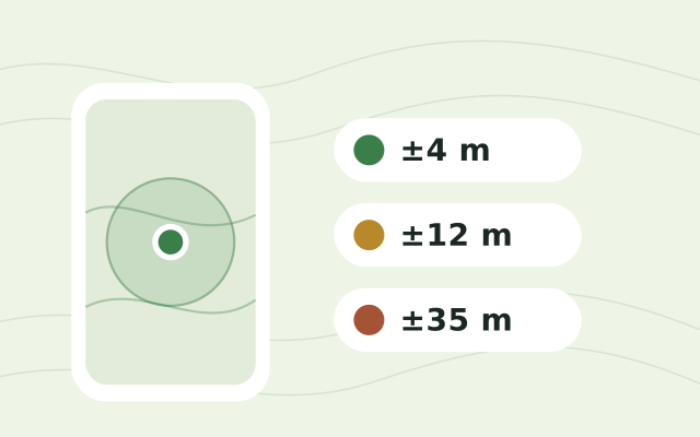
For tracking new plantings after they go in the ground, see how to track tree planting survival. To check your crews' phones before a survey, use the free GPS accuracy test.
Talk through your tree inventory with us
If your tree records, planting and volunteer work live in different places, a short call is the quickest way to see whether we fit. We'll look at what you track today, who updates it, and which tools above you already use. If a municipal inventory system is what you need, we'll say so. If not, we'll show how your trees and sites would look joined up. Book a call.
Frequently asked questions
What is urban tree inventory software?
Software that keeps a record of every street and park tree a city or organisation manages, with its location, species, size and condition, and the inspections and maintenance done on it. Many products also add work orders, risk assessment, a public map, or estimates of the benefits trees provide.
What is the best tree inventory software for a city?
It depends on the region and the job. In the US, TreePlotter and TreeKeeper are the established options, and Esri's Tree Management suits cities already on ArcGIS. In the UK, Ezytreev and Arbortrack serve councils. In Europe, R3 GIS GreenSpaces covers inventory, stability assessments and a public portal.
How much does tree inventory software cost?
Few vendors publish prices. Davey's TreeKeeper costs $3,600 or $8,000 a year for its first two tiers, and a PlanIT Geo page says TreePlotter starts from $1,500 a year. Ezytreev's G-Cloud listing gives £1,000 a licence a year. QField is free, with paid cloud sync from €18 per user a month billed annually. Arbortrack, R3 GIS, greehill and Restoration Scope quote on request.
Is i-Tree still available?
Yes, as of October 2026, and it's still free. The USDA Forest Service halted its traditional hosting and maintenance funding in December 2025, though some project funding continues, and i-Tree says the tools could eventually stop working. Its team has committed to give at least six months' notice before a core tool goes offline.
What happened to OpenTreeMap?
Its open-source code on GitHub hasn't been updated since August 2023. If you're considering it, confirm who still hosts and maintains it before relying on it.
Can a tree inventory work offline?
Yes, with most tools here. TreePlotter (with its Offline Collector add-on), TreeKeeper, ArborPro, Esri Field Maps, Ezytreev, Arbortrack, R3 GIS, QField and Restoration Scope all record in the field without a connection. i-Tree Eco's mobile forms cache data on compatible devices; test them in airplane mode first.
Can residents see the city's trees on a public map?
With several tools, yes. TreePlotter has a Community Engagement Map, TreeKeeper a public Guest View, Ezytreev ezyPortal, R3 GIS a public portal, ArborPro a Community Viewer share link, and Esri's Tree Management a public Hub site.