Best Impact Reporting Software for Nature Funders in 2026: The Buyer's Shortlist
The best impact reporting software for nature funders in 2026, by job: grant workflow, restoration portfolios, satellite checks and donor portals.
What is the best impact reporting software for nature funders in 2026?
The best impact reporting software for nature funders in 2026 depends on what you need to see. For grant applications, payments and reports, Fluxx, Submittable or Salesforce Nonprofit Cloud. For a restoration portfolio on a map, Restor or explorer.land, both with published prices. For free independent checks, Global Nature Watch. For donor portals built from your grantees' own records, Restoration Scope.
As of October 2026: facts about each tool come from its own website or documentation, linked in each entry, and were checked on October 19, 2026. Prices change; confirm them with the provider.
Key takeaways
- Grant software is built around money; restoration software around land. Fluxx, Submittable, Salesforce and UpMetrics are built for grants and outcome reports; some show locations on a map, but none documents site monitoring or satellite checks. Restoration platforms are built the other way round.
- Two restoration platforms publish prices. explorer.land charges per project per month, and Restor Insights charges a yearly tier with portfolio and hectare limits. Per-project pricing grows with your portfolio, so model both for your project count.
- Satellite checks are free; field evidence isn't. Global Nature Watch shows forest change for free, but it can't tell you whether last season's seedlings survived. That comes from the grantees' records.
- Tree-buying platforms report on their own project networks. veritree, Tree-Nation and Ecologi show companies the trees they funded through them. If you already fund grantees directly, ask whether they can be brought in.
- Ask who enters the field data. Satellite checks run without grantees, but field evidence and outcomes need grantees to keep records current. The less extra work a tool asks of them, the more likely the data stays fresh.
What impact reporting software for nature funders is (and what it isn't)
A nature funder gives money to projects that restore or protect land: a foundation with a restoration programme, a company funding trees through a nonprofit, or a fund backing many local groups. Impact reporting software shows that funder, and its own donors or board, what the money did.
It covers five jobs:
- Grant workflow: applications, reviews, payments, and scheduled reports from grantees.
- Portfolio view: every funded project in one place, by location, grantee and funding relationship.
- Field evidence: what grantees record on the ground, such as sites, planting, survival and photos.
- Independent checks: satellite data on tree cover and land use change, read without asking the grantee.
- Donor and public views: portals, embedded maps and public pages for the funder's own supporters.
It isn't a certification or an audit. Software shows what the records and the satellite data say; it can't confirm that the land is legally secured, that trees will survive, or that work wouldn't have happened anyway. It also isn't a substitute for the grantees' own monitoring: if a grantee doesn't record survival, no funder dashboard will show it. For how funders set up monitoring with their grantees, see our guide to a restoration monitoring system for funders.
How we chose these tools
We checked each tool on five criteria you can verify on its own website:
- Jobs covered: how many of the five jobs above the tool's own site says it does.
- Built for restoration: whether it names restoration, forests or nature projects, or is general grant software.
- Your choice of projects: whether you report on grantees you choose, or only on projects the vendor supplies.
- Published price: whether its price is on its website, and the entry price.
- Data you keep: whether it states an export or API for your data.
We didn't score ease of use, support or data accuracy, because we can't measure them fairly across tools. This is an editorial shortlist by job, not a ranking: tools are numbered in the order a funder meets each job, from the grant cycle to the donor's view. Restoration Scope, our own product, comes last.
The best impact reporting software for nature funders in 2026
Eleven tools, grouped by the job each is built for: grant workflow, restoration portfolios, independent checks, and donor views.
1. Fluxx, best for foundations managing the full grant cycle
Fluxx is grants management software for private foundations and government funders, covering applications, reviews, approvals, payments, compliance and reporting, with personalized grantee portals. It says it manages more than $39 billion in funding a year and supports more than 200,000 grantees. It integrates with other systems, including Google Maps to show where grants and organisations are, and has an API. We found no site monitoring or satellite data in its documentation. Price not published.
Best suited for: foundations with many grants across themes, where nature is one programme among several. Pair it with a restoration platform if you want to see the sites.
2. Submittable, best for running open calls and post-award reports
Submittable runs applications, reviews, awards, payments and scheduled progress reports, with a drag-and-drop form builder and a public API. It says its customers manage more than $5 billion in funds across more than 200,000 programmes, and it has been around since 2010. Prices aren't published; its pricing page books a meeting.
Best suited for: funders running open calls for restoration grants, including corporate giving teams. We found no site monitoring or satellite data in its documentation.
3. Salesforce Nonprofit Cloud, best for funders already on Salesforce
Salesforce Nonprofit Cloud has a grantmaking edition for applications, reviews, awards, grantee budgets and progress reports, with branded portals for grantseekers. Nonprofit editions cost $70, $125 or $285 per user a month, billed annually; grantmaking comes with the $285 Max editions. Eligible nonprofits get 10 Core licences free. Salesforce Maps is in the Max editions, but it isn't built for monitoring land.
Best suited for: organisations whose donations and grants already live in Salesforce. Many need an implementation partner to set it up.
4. UpMetrics, best for outcome dashboards across a portfolio
UpMetrics collects outcome data from grantees and portfolio companies through report requests, then builds dashboards across the portfolio. It serves grantmakers, nonprofits and impact investors, and its dashboards include map widgets for locations. Customers own their data and can export it as CSV. We found no site monitoring or satellite data. Funder pricing is by quote.
Best suited for: funders who report on social and environmental outcomes together and want grantee numbers in one dashboard rather than in PDFs.
5. Restor, best for a restoration portfolio with yearly pricing
Restor is a Swiss nonprofit map platform for nature sites, with more than 30 free ecological datasets per site. Its paid Restor Insights plans add portfolio dashboards where partners upload ground data, disturbance alerts, sharing and embeds, and a white-label microsite on higher tiers. Insights costs CHF 1,400, 5,000 or 15,000 a year (CHF 980, 3,500 or 10,500 for NGOs), with 10, 50 or unlimited portfolios and CHF 20 a year per extra 10,000 hectares (CHF 16 above a million). It says it connects more than 343,000 sites and 7,500 organisations.
Best suited for: funders and networks comparing many sites with the same datasets. Restor notes that data on Restor doesn't equal ownership of the land. See our explorer.land alternatives for how it compares with map-first tools.
6. explorer.land, best for map pages per funded project
explorer.land, from OpenForests, lets projects map their sites, track satellite indicators updated monthly, post stories and give funders a branded map view of what they supported. It has a free plan for one project; Starter costs €49 and Pro €99 per project a month (€34 and €69 billed yearly), with sponsor management and white label on Pro. It says it hosts more than 2,000 projects from more than 900 organisations.
Best suited for: funders whose grantees each want their own public project page. Pricing is per project, so a large portfolio adds up. See explorer.land vs Restoration Scope.
7. Global Nature Watch, best for free independent forest checks
Global Nature Watch, formerly Global Forest Watch, is WRI's free map of forest change, with alerts. Its Forest Watcher app takes the data into the field offline and records field reports with photos, which teams can manage and export. It's built for monitoring forests rather than reporting to donors.
Best suited for: funders who want to check forest loss around funded sites themselves, at no cost. It shows canopy change, not the survival of young seedlings.
8. ArcGIS Hub and StoryMaps, best for funders with GIS staff
ArcGIS Hub and
ArcGIS StoryMaps publish public data sites and map-based stories, and come with ArcGIS Online user types (Hub Premium is licensed separately). Field teams can collect data with ArcGIS field apps under the Mobile Worker user type. Esri sells ArcGIS Online as annual user licences; its nonprofit programme lists ArcGIS Online at $100 a year.
Best suited for: funders with a GIS team who want full control of the map and story. You build the portfolio model yourself; nothing comes set up for restoration.
9. Plant-for-the-Planet ForestCloud, best free option for grantees raising their own donations
ForestCloud, from Plant-for-the-Planet, lets restoration organisations list projects, take donations at 0% commission, monitor sites with the offline TreeMapper app, publish their monitoring data with one click, and get free fire alerts; satellite carbon estimates are marked as coming soon. Projects report progress regularly, including site shapes, species, tree counts and survival. It's free for nonprofits and communities, and data can be downloaded or reached through an API.
Best suited for: small grantees who want a free public page and donation flow. It's built for the organisation doing the work; we found no view for a funder across other organisations.
10. veritree, best for companies buying verified planting
veritree sells companies verified tree planting, tracked with geotagged photos, drones and, from year five, satellite imagery, and reported in a shareable impact dashboard and a portal for orders, goals and progress across projects, with API access to planting sessions and evidence. It says it has planted more than 159.5 million verified trees. Prices aren't published; its site invites investments over $5,000.
Best suited for: companies that want to buy planting and a report together. The dashboard covers projects in veritree's planting network; if you already fund grantees, ask whether they can be brought in.
11. Restoration Scope, best for donor portals built from grantees' own records
Restoration Scope (that's us) builds digital infrastructure for nature projects: we connect a team's field data, maps and workflows so they can see their operations and show funders credible evidence. For funders, that means one portal per donor or partner, built from the records that already exist: donations in Salesforce, projects in Airtable, field updates in a spreadsheet. Access is set for each audience, so a portal can be public or private to one donor.
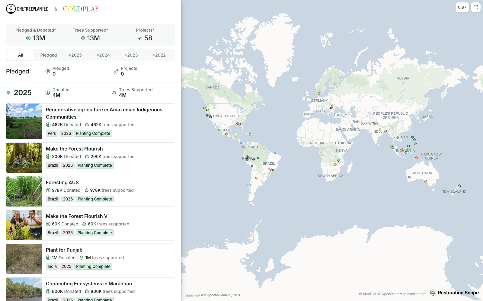
The Coldplay x One Tree Planted portal.
Totals, then each project with its photo, amount and status, beside a map of the supported projects. Public partner portal.
We're not grant management software and we don't sell satellite data, so pair us with a grant tool if you need applications and payments, and with a satellite source for independent checks. Pricing is a free demo, then a platform license plus implementation, quoted after a scoping call.
Best suited for: funders and intermediaries whose project data already lives in several systems and who want each donor to see their own work without a report to assemble. See Restoration Scope for donor reporting.
Also considered
TerraMatch, WRI's system behind TerraFund for AFR100, combines six-monthly grantee reports, geotagged and drone photos, and satellite tree counts across 251 funded projects. We found no public pricing or way for other funders to buy it, and TerraFund now invites projects rather than running open calls.
GainForest is a Swiss nonprofit where communities publish signed public impact records and donors fund them, with an open API. It's a community and donor model rather than funder software.
Tree-Nation (from €0.35 a tree) and
Ecologi (from £5.35 per employee a month) give companies a public impact page for trees they fund through their project networks, like veritree.
Side-by-side comparison
Checked on the five criteria above, from each tool's own website as of October 2026. "Jobs" counts the five jobs listed earlier.
| Tool | Best for | Jobs covered (of 5) | Built for restoration | Your choice of projects | Published price | Data you keep |
|---|---|---|---|---|---|---|
| Fluxx | Full grant cycle | 2: grant workflow, portfolio | No, general grantmaking | Yes | No | Yes, API |
| Submittable | Open calls and reports | 2: grant workflow, portfolio | No, general grantmaking | Yes | No | Yes, public API |
| Salesforce Nonprofit Cloud | Funders on Salesforce | 2: grant workflow, portfolio | No, general CRM | Yes | Yes, grantmaking $285/user/month billed annually | Yes, platform APIs |
| UpMetrics | Outcome dashboards | 3: post-award reports, portfolio, donor views | No, general impact data | Yes | No | Yes, CSV exports |
| Yearly-priced portfolios | 4: portfolio, field evidence, checks, donor views | Yes | Yes | Yes, from CHF 1,400/year | Partly, site-list CSV export | |
| Per-project map pages | 4: portfolio, field evidence, checks, donor views | Yes | Yes | Yes, free; from €34/project/month billed yearly | Partly, custom API integrations | |
| Free forest checks | 2: field evidence, checks | Yes, forests | Yes | Yes, free | Yes, downloads | |
| ArcGIS Hub and StoryMaps | Funders with GIS staff | 4: portfolio, field evidence, checks, donor views (you build them) | No, general GIS | Yes | Partly, nonprofit $100/year | Yes |
| Grantees raising donations | 2: field evidence, donor views | Yes | Partly, per organisation | Yes, free | Yes, downloads and API | |
| veritree | Companies buying planting | 4: portfolio, field evidence, checks, donor views | Yes | Partly, its planting network | No | Yes, API for planting sessions and evidence |
 Restoration Scope | Donor portals from existing records | 3: portfolio, field evidence, donor views | Yes | Yes | No | Yes, CSV and geospatial exports |
Which tool fits your situation
| Your situation | Start with | Add | Watch out for |
|---|---|---|---|
| Foundation with many grants across themes | Fluxx or Submittable | Restor or explorer.land for the nature programme | Site data that never reaches the grant record |
| Grants and donors already in Salesforce | Salesforce Nonprofit Cloud | A portal fed from Salesforce and field records | Internal user licences; portal logins are counted separately |
| A restoration portfolio you want to compare | Restor | Global Nature Watch for free checks | Grantees uploading data in two places |
| Each grantee wants a public project page | explorer.land | A grant tool for payments | Per-project pricing as the portfolio grows |
| Company buying trees, no grantees of its own | veritree, Tree-Nation or Ecologi | — | Reports cover their own project networks |
| Donors who each want to see their own projects | Restoration Scope | A grant tool for applications | No published price; scoped per setup |
By role: programme officers usually own the grant tool, monitoring and evaluation leads the restoration platform and satellite checks, and communications teams the donor portal and public pages.
What results look like
Our funder work so far is with intermediaries that pass money from donors to restoration groups:
One Tree Planted funds reforestation with local partners worldwide. We built a tool that generates a portal for each of their donors, under both names. Coldplay's portal is public; the others stay private to each donor.
- Acción Andina connects 16 partner organizations across 6 Andean countries. We joined 120 seasons of data from 23 projects into one database and map, so funders see the same data the programme works from, with no report to prepare.
See all our partners, or read the Acción Andina case study.
How do you choose impact reporting software as a funder?
- Separate the money from the land. Decide whether your gap is the grant cycle, the view of the sites, or what your own donors see. Many funders need two tools, not one.
- Price your real portfolio. Vendors charge per project (explorer.land), per yearly tier with portfolio and hectare limits (Restor) or per user (Salesforce). Model your projects, hectares and users, not the entry plan.
- Ask what grantees have to do. A tool that makes every grantee re-enter data in a new format adds reporting work. Prefer one that reads what they already keep.
- Check independently, but know the limits. Free satellite data shows forest loss and canopy change; it doesn't show whether seedlings survived. Ask grantees for survival records too, and see how to track tree planting survival.
- Plan for your own donors. If your supporters will see the results, decide early what stays private and what goes on a public page.
For more on the tools grantees use in the field, see restoration monitoring tools compared.
Talk through your funder reporting with us
If your grantees' records live in spreadsheets, forms and databases and your donors want to see their projects, a short call is the quickest way to see whether we fit. We'll look at what your grantees track today, what each donor should see, and which tools above you already use. If a grant tool and a spreadsheet are enough, we'll say so. If not, we'll show how a setup like One Tree Planted's would look with your data. Book a call.
Frequently asked questions
What software do nature funders use for impact reporting?
Many use two kinds. Grant management software such as Fluxx, Submittable or Salesforce Nonprofit Cloud runs applications, payments and grantee reports. A restoration platform such as Restor or explorer.land, or a portal built on the grantees' own records, shows where the funded work is and how the sites are doing.
What is the difference between grant management software and restoration monitoring software?
Grant management software tracks the money and the paperwork, from application to final report. Restoration monitoring software tracks the land, with site boundaries, field records, photos and satellite data. Few tools do both, so funders with a nature portfolio often pair one of each.
Can a funder see grantees' field data without asking for reports?
Yes, if the grantees' records feed a shared view. Restor lets partners upload ground data to a funder's dashboard, explorer.land aggregates partner sites into one map, and Restoration Scope builds portals from the records grantees already keep. Each still needs grantees to keep their records current.
How can a funder check restoration claims independently?
With satellite data. Global Nature Watch (formerly Global Forest Watch) is free and shows forest loss alerts, Restor includes over 30 free ecological datasets, and explorer.land updates satellite indicators monthly. Satellites show canopy and land cover change, not survival of young seedlings, so pair them with field records.
How much does impact reporting software for funders cost?
It ranges widely. explorer.land is free for one project and then €34 to €69 per project a month billed yearly; Restor Insights costs CHF 1,400 to 15,000 a year, less for NGOs; Salesforce Nonprofit Cloud for Grantmaking is $285 per user a month billed yearly. Fluxx, Submittable, UpMetrics and Restoration Scope quote on request.
Do grantees have to change their tools?
It depends on the integration. Grant portals usually ask grantees to fill in their forms. Some platforms document integrations with existing systems, such as explorer.land's custom API work and UpMetrics' connections to spreadsheets and survey tools. Restoration Scope connects the spreadsheets, forms and databases grantees already use. Ask each vendor how your grantees' current records would get in.
How can a funder show donors where their trees were planted?
With a map built from the planting partners' site records. explorer.land and Restor give funders a branded map of supported sites, and Restoration Scope builds a portal per donor from the partners' records, such as the public Coldplay and One Tree Planted portal at restorationscope.com/one-tree-planted/coldplay.
Can each donor have their own portal?
Yes, with some tools. explorer.land's Pro plan adds sponsor management and white label, Restor's higher tiers include a white-label microsite, and Restoration Scope builds a portal per donor, as it does for One Tree Planted, where Coldplay's portal is public and the others stay private.